This selection is provided by Visiorando, one the best hiking ressource around. You can access the original and complete information, by scanning the 2D tag attached to each of these hiking suggestions.
| Name | Drive from home | Circular | Distance | Duration | Difficulty |
|---|---|---|---|---|---|
| Overlooking Beaulieu-sur-Dordogne | 8 mn | yes | 6,2 km | 2h40 | Easy |
| The Doux Castle | 8 mn | yes | 10 km | 3h45 | Mid |
| The Dordogne river valley around Monceaux | 27 mn | yes | 14 km | 5h30 | Mid |
| Gorges de la Cère, de Laval-de-Cère à Laroquebrou | 15 mn | no | 34 km | 10h | Difficult |
| Dordogne valley beneath Servières-le-Château | 38 mn | yes | 7,1 km | 3h | Mid |
| Around the Turenne citadel | 40 mn | yes | 6,3 km | 2h15 | Easy |
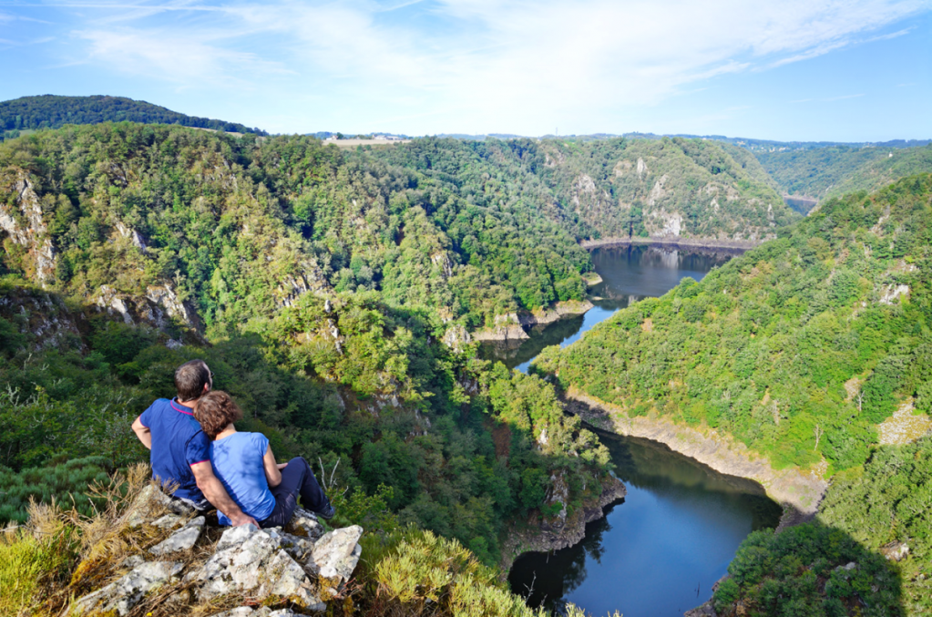
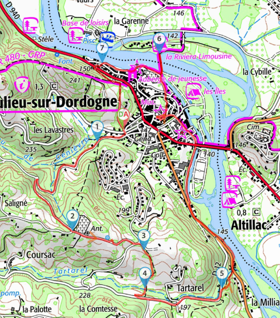
Overlooking Beaulieu-sur-Dordogne
Nice hike overlooking the Dordogne river valley and Altillac, and ending at Beaulieu-sur-Dordogne.
- Duration : 2h40
- Distance = 6,2 km
- Elevation + = 307 m
- Elevation – = 354 m
- Highest : 336 m
- Lowest : 152 m
- Difficulty : Easy
- Circular : Yes

Waypoints
- Start/End : Champ de Mars – Parking
N 44.978419° / E 1.835331° – alt. 206 m – km 0 - Chemin possible
N 44.977692° / E 1.833147° – alt. 224 m – km 0.23 - Cimetière – highest
N 44.97237° / E 1.831067° – alt. 334 m – km 1.37 - chemin entre prairies
N 44.971206° / E 1.837064° – alt. 303 m – km 1.93 - Pont sur le Ruisseau de Tartarel
N 44.968954° / E 1.837154° – alt. 259 m – km 2.24 - Le long du Tartarel
N 44.968956° / E 1.843636° – alt. 234 m – km 3.01 - Passerelle – Dordogne (rivière) – Affluent de la Garonne
N 44.982925° / E 1.838365° – alt. 198 m – km 4.99 - Venelle
N 44.982381° / E 1.833565° – alt. 199 m – km 5.56 - Start/End Champ de Mars – Parking
N 44.978452° / E 1.835353° – alt. 158 m – km 6.16
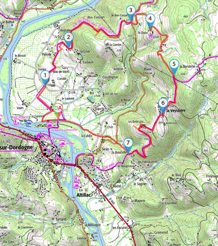
The Doux Castle
Starting in the valley, the trail reaches the heights of Altillac. Along the way, observe the mixed influences of the Quercy region (on the houses) and the Cantal region (on the barns).
- Duration : 3h45
- Distance = 10 km
- Elevation + = 300 m
- Elevation – = 302 m
- Highest : 426 m
- Lowest : 141 m
- Difficulty : Mid
- Circular : Yes

Waypoints
- D/A Parking village vacances – Dordogne (rivière) – Affluent de la Garonne
N 44.984316° / E 1.840296° – alt. 144 m – km 0 - D116
N 44.989395° / E 1.837554° – alt. 159 m – km 1.11 - Voie goudronnée
N 44.995269° / E 1.842627° – alt. 213 m – km 2.22 - Le Bos Cassan, croisement
N 44.999411° / E 1.856215° – alt. 336 m – km 4.01 - Château du Doux
N 44.998133° / E 1.860428° – alt. 379 m – km 4.77 - GR480
N 44.991104° / E 1.865629° – alt. 426 m – km 6.11 - La Veyssière
N 44.985131° / E 1.863211° – alt. 360 m – km 6.91 - La Bourelle
N 44.978981° / E 1.855629° – alt. 200 m – km 8.59 - D/A Parking village de vacances
N 44.98431° / E 1.840473° – alt. 144 m – km 10
The Dordogne river valley around Monceaux
Pleasant circuit with nice viewpoints just after Monceaux, which is a traditional village next to the Dordogne river. Between July 11th and August 29th, renowned farmer’s market on the Church square starting at 17h every Thursdays.
- Duration : 5h30
- Distance = 14 km
- Elevation + = 511 m
- Elevation – = 503 m
- Highest : 460 m
- Lowest : 182 m
- Difficulty : Mid
- Circular : Yes

Waypoints
- Departure/Arrival War memorial parking
N 45.081624°|E 1.907727° – alt.182 m – km 0 - Wood panel
N 45.078782°|E 1.915361° – alt.267 m – km 0.97 - Viewpoint
N 45.081599°|E 1.921498° – alt.379 m – km 1.98 - Viewpoint on the crest
N 45.087417°|E 1.914682° – alt.348 m – km 3.28 - Road to the right
N 45.083415°|E 1.906044° – alt.192 m – km 4.77 - Trail to the right
N 45.084187°|E 1.900229° – alt.200 m – km 5.78 - Small water stream (Ru)
N 45.088633°|E 1.8889° – alt.324 m – km 7.27 - Trail to the left
N 45.086538°|E 1.882264° – alt.437 m – km 8.57 - Old road facing
N 45.077174°|E 1.888546° – alt.450 m – km 9.76 - Chemin à gauche
N 45.069791°|E 1.89347° – alt.443 m – km 10.68 - Paraglider take-off area
N 45.066575°|E 1.899392° – alt.460 m – km 11.35 - Salle hamlet, next to the Dordogne river
N 45.074417°|E 1.903394° – alt.231 m – km 12.82 - Departure/Arrival War memorial parking
N 45.081623°|E 1.907714° – alt.182 m – km 13.83

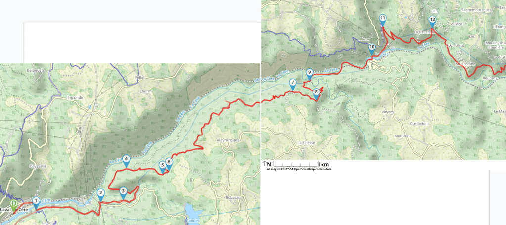
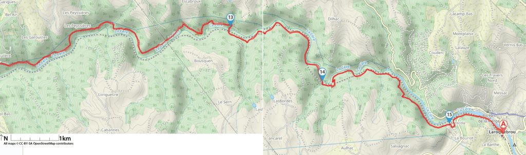
Gorges de la Cère, de Laval-de-Cère à Laroquebrou
You will need two cars for this one, as the starting point differs from the arrival one. Only for seasoned hikers (long with substantial positive elevation). Otherwise very wild setting within the Gorges de la Cère. Mostly under tree coverage.
- Duration : 10h
- Distance = 34,6 km
- Elevation + = 1881 m
- Elevation – = 1603 m
- Highest : 544 m
- Lowest : 173 m
- Difficulty : Difficult
- Circular : No

Waypoints
- Departure Laval-de-Cère, SNCF train station
N 44.951251° / E 1.931556° – alt. 173 m – km 0 - Jonction avec le GR652 – Pont sur la – Cère (rivière)
N 44.95175° / E 1.937457° – alt. 177 m – km 0.7 - Pylône haute tension
N 44.953215° / E 1.954676° – alt. 279 m – km 2.4 - Le balisage Jaune nous rejoint
N 44.953559° / E 1.960653° – alt. 287 m – km 2.89 - Fourche — monter à droite
N 44.959623° / E 1.961457° – alt. 268 m – km 4.78 - Carrefour Cargadou – à gauche
N 44.958454° / E 1.971113° – alt. 435 m – km 5.68 - Carrefour au bord d’un pré – à gauche
N 44.959054° / E 1.972797° – alt. 460 m – km 5.83 - Bifurcation
N 44.973777° / E 2.004233° – alt. 472 m – km 10.41 - Sentier de la Gare
N 44.971809° / E 2.010906° – alt. 473 m – km 11.04 - Passerelle accolée à l’aqueduc
N 44.975816° / E 2.009018° – alt. 275 m – km 12.31 - Pont sur la Cère, Lamativie
N 44.980916° / E 2.026828° – alt. 292 m – km 14.22 - Chemin de terre vers la droite
N 44.986765° / E 2.029933° – alt. 358 m – km 15.1 - Déversoir
N 44.986471° / E 2.04408° – alt. 437 m – km 17.07 - Descente vers Siran
N 44.986016° / E 2.126048° – alt. 419 m – km 26.28 - Fin du Tunnel de Lasbordes
N 44.974206° / E 2.145594° – alt. 455 m – km 29.12 - Mini-golf
N 44.966236° / E 2.179046° – alt. 463 m – km 33.04 - Arrival Laroquebrou
N 44.964456° / E 2.193232° – alt. 449 m – km 34.56
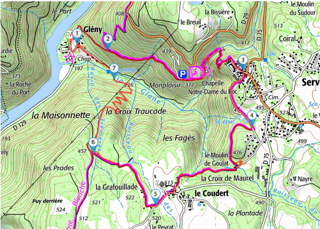
Dordogne valley beneath Servières-le-Château.
On the sunny side of the Dordogne valley, can combined with the visit of the nearby Chastang dam.
- Duration : 3h00
- Distance = 7,1 km
- Elevation + = 331 m
- Elevation – = 314 m
- Highest : 511 m
- Lowest : 202 m
- Difficulty : Mid
- Circular : Yes

Waypoints
- Start/End Ancienne école (Glény). Vallée de la Dordogne (rivière)
N 45.134213° / E 2.004071° – alt. 202 m – km 0 - Carrefour de la boucle
N 45.134305° / E 2.004866° – alt. 211 m – km 0.13 - Tout droit à l’embranchement
N 45.133893° / E 2.008184° – alt. 277 m – km 0.64 - À droite Circuit du Roc d’Astier
N 45.132287° / E 2.022723° – alt. 479 m – km 2.32 - À droite sur large allée (haie haute conifères)
N 45.128075° / E 2.023662° – alt. 488 m – km 2.91 - À droite à la fourche
N 45.122104° / E 2.013301° – alt. 507 m – km 4.45 - Tout droit à l’embranchement
N 45.126034° / E 2.006595° – alt. 469 m – km 5.27 - À droite après la ruine
N 45.131663° / E 2.00884° – alt. 242 m – km 6.65 - Start/End Ancienne école (Glény)
N 45.134385° / E 2.004877° – alt. 212 m – km 7.11
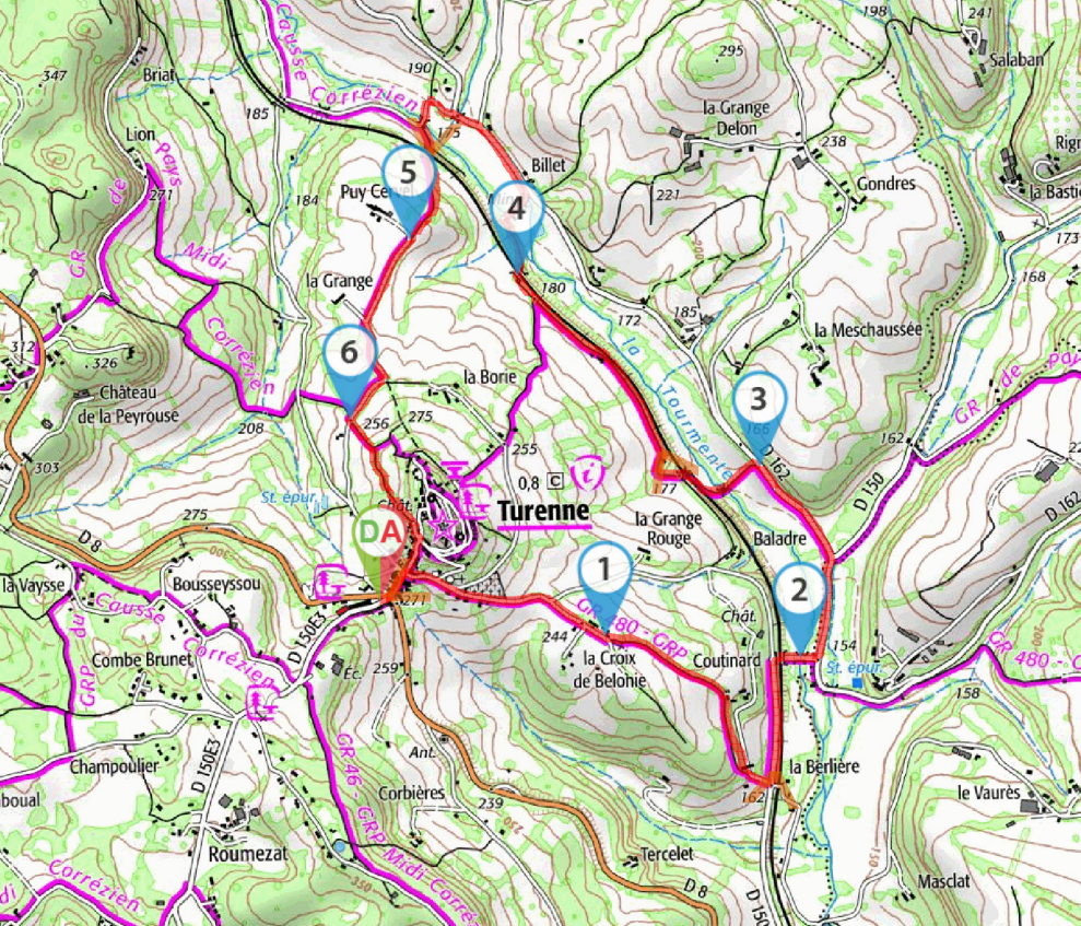
Around the Turenne citadel
An easy stroll around one of France’s prettiest village. Should be combined with a visit of nearby Collonges-la-Rouge.
- Duration : 2h15
- Distance = 6,3 km
- Elevation + = 160 m
- Elevation – = 158 m
- Highest : 307 m
- Lowest : 152 m
- Difficulty : Easy
- Circular : Yes

Waypoints
- Start/End Place de l’Office de Tourisme
N 45.05338° / E 1.581372° – alt. 271 m – km 0 - Croix de Bélonie
N 45.052394° / E 1.590068° – alt. 244 m – km 0.79 - Pont sur la Tourmente (water stream)
N 45.051839° / E 1.597573° – alt. 156 m – km 1.99 - Quitter la D162, descendre à gauche
N 45.05703° / E 1.596009° – alt. 163 m – km 2.7 - Passage sous la voie ferrée
N 45.062214° / E 1.586673° – alt. 181 m – km 3.84 - Piste, continuer tout droit
N 45.063184° / E 1.58251° – alt. 219 m – km 5.02 - Chemin bordé de haies d’arbres
N 45.058296° / E 1.580236° – alt. 256 m – km 5.65 - Start/End Place de l’Office de Tourisme
N 45.053442° / E 1.581609° – alt. 274 m – km 6.3

Leave a comment